You Will Return to Iceland. Everyone Does.
Iceland does something to photographers that few destinations manage: it makes you feel simultaneously small and creatively charged. Within a single day’s drive, you can photograph glaciers calving into lagoons, waterfalls thundering over basalt columns, volcanic beaches where ice diamonds scatter across black sand, and geothermal vents steaming against a twilight sky. The entire island is a 103,000-square-kilometer studio, and the light, when it cooperates, is unlike anything you have experienced.
But Iceland also punishes the unprepared. Weather changes in minutes. Iconic locations draw crowds that can ruin a composition. Roads close without warning. And the “midnight sun” that sounds romantic means you may struggle to find the dramatic low-angle light that makes landscape photography sing, unless you understand the seasonal rhythms.
This guide covers 27 locations organized around the Ring Road circuit. Each includes GPS coordinates, best shooting conditions, and the practical details that only matter when you are actually standing there with a camera.
Sign up to see photography location maps
South Coast: The Classic Circuit
The south coast is where most photographers begin, and for good reason. The concentration of world-class locations within a 300-kilometer stretch is unmatched anywhere on the island.
1. Seljalandsfoss
GPS: 63.XX°N, 19.XX°W🔒 | Best light: Sunset (west-facing) | Difficulty: Easy
The waterfall you can walk behind. That feature alone makes Seljalandsfoss one of the most photographed waterfalls on Earth, but the images most people make here are mediocre. The classic “behind the falls” shot requires careful positioning to avoid the worst of the spray while framing the cascade with the green valley beyond.
Field notes:
- Waterproof your camera with a rain sleeve, not just a lens cloth. The spray is constant and heavy.
- Sunset light filters through the water from the west, creating a translucent golden curtain. This is the shot. Arrive 90 minutes before sunset.
- Early morning (before 8 AM in summer) gives you the falls nearly alone. By 10 AM, the path behind the falls becomes a queue.
- The lesser-known Gljufrabui waterfall is a 5-minute walk south. It hides inside a slot canyon and rewards those who wade through the stream entrance.
2. Skogafoss
GPS: 63.XX°N, 19.XX°W🔒 | Best light: Morning (east-facing) | Difficulty: Easy to moderate
A 60-meter curtain waterfall with a reliable rainbow on sunny mornings. The scale of Skogafoss is difficult to convey in photographs, which is precisely the challenge.
Field notes:
- Position yourself on the left bank with a wide-angle lens to capture the full curtain with rainbow arc. The rainbow appears between roughly 8-10 AM when sun angle and spray align.
- Climb the 527 steps to the top for an aerial perspective and access to the Fimmvorduhals trail, which passes between Eyjafjallajokull and Myrdalsjokull glaciers.
- A shutter speed of 1/4 second balances the waterfall’s power with just enough silk effect. Full long exposure loses the drama.
- Include a person at the base for scale. The falls are 25 meters wide, and without a human reference, they can read as far smaller than they are.
3. Jokulsarlon Glacier Lagoon
GPS: 64.XX°N, 16.XX°W🔒 | Best light: Sunrise and blue hour | Difficulty: Easy
Icebergs calving from Breidamerkurjokull glacier drift through a lagoon that feels prehistoric. The blue and white ice against dark water creates natural abstractions that practically compose themselves.
Field notes:
- Sunrise is the prime window. The low-angle light catches the ice faces and creates dramatic color contrasts.
- Use a 70-200mm telephoto to isolate individual bergs with clean compositions. Wide-angle shots of the lagoon are beautiful but common.
- Blue hour delivers the deepest saturation in the ice. The interplay of ambient blue light and the ice’s trapped air bubbles produces a color palette you will not find in any other landscape.
- Seal heads frequently break the surface. A 200mm+ lens at 1/500s captures them between ice formations.
- Zodiac boat tours put you among the bergs for a unique low perspective.
4. Diamond Beach
GPS: 64.XX°N, 16.XX°W🔒 | Best light: Sunrise | Difficulty: Easy
Directly across the road from Jokulsarlon, ice chunks wash onto black volcanic sand. The contrast is extraordinary.
Field notes:
- New ice appears after storms. The day after rough weather produces the best “diamonds.”
- Long exposure (2-8 seconds) smooths the surf around ice pieces, creating a ethereal effect. Use ND filters.
- Get low. A ground-level perspective with a wide-angle lens makes small ice pieces monumental.
- The beach faces east, so sunrise light backlights the ice, creating translucent glowing effects.
- Watch for waves. The surf is unpredictable and powerful. Never turn your back to the ocean.
5. Reynisfjara Black Sand Beach
GPS: 63.XX°N, 19.XX°W🔒 | Best light: Any (dramatic in all conditions) | Difficulty: Easy
Safety warning: Sneaker waves at Reynisfjara have killed multiple tourists. The waves here are genuinely lethal. Never walk near the waterline, never turn your back to the ocean, and watch wave patterns for several minutes before approaching.
The hexagonal basalt columns, the Reynisdrangar sea stacks, and the black sand create one of the most dramatic coastal landscapes on Earth.
Field notes:
- Use the basalt columns as a leading line or frame. At wide angle (16-24mm), the columns create powerful geometry converging toward the sea stacks.
- The sea stacks photograph well at telephoto focal lengths (100-200mm) from the beach, compressed against stormy skies.
- Stormy days produce the most dramatic images. The combination of crashing waves, dark sand, and moody skies is exactly what this location demands.
- A polarizer removes glare from wet basalt columns, deepening their color and texture.
6. Dyrholaey
GPS: 63.XX°N, 19.XX°W🔒 | Best light: Late evening | Difficulty: Easy
A promontory with a natural rock arch, lighthouse, and sweeping views of the south coast in both directions. In summer (May-August), this is a puffin nesting site.
Field notes:
- Access is via two separate viewpoints. The lower road reaches the arch; the upper road reaches the lighthouse.
- Evening light on the arch is exceptional. Position the arch to frame the distant Myrdalsjokull glacier.
- During puffin season, the upper cliffs offer close encounters without disturbing the nests. A 200-400mm lens fills the frame.
- The upper viewpoint provides one of the best panoramic compositions on the south coast: black beach stretching west toward Vik with waves creating white lines on the sand.
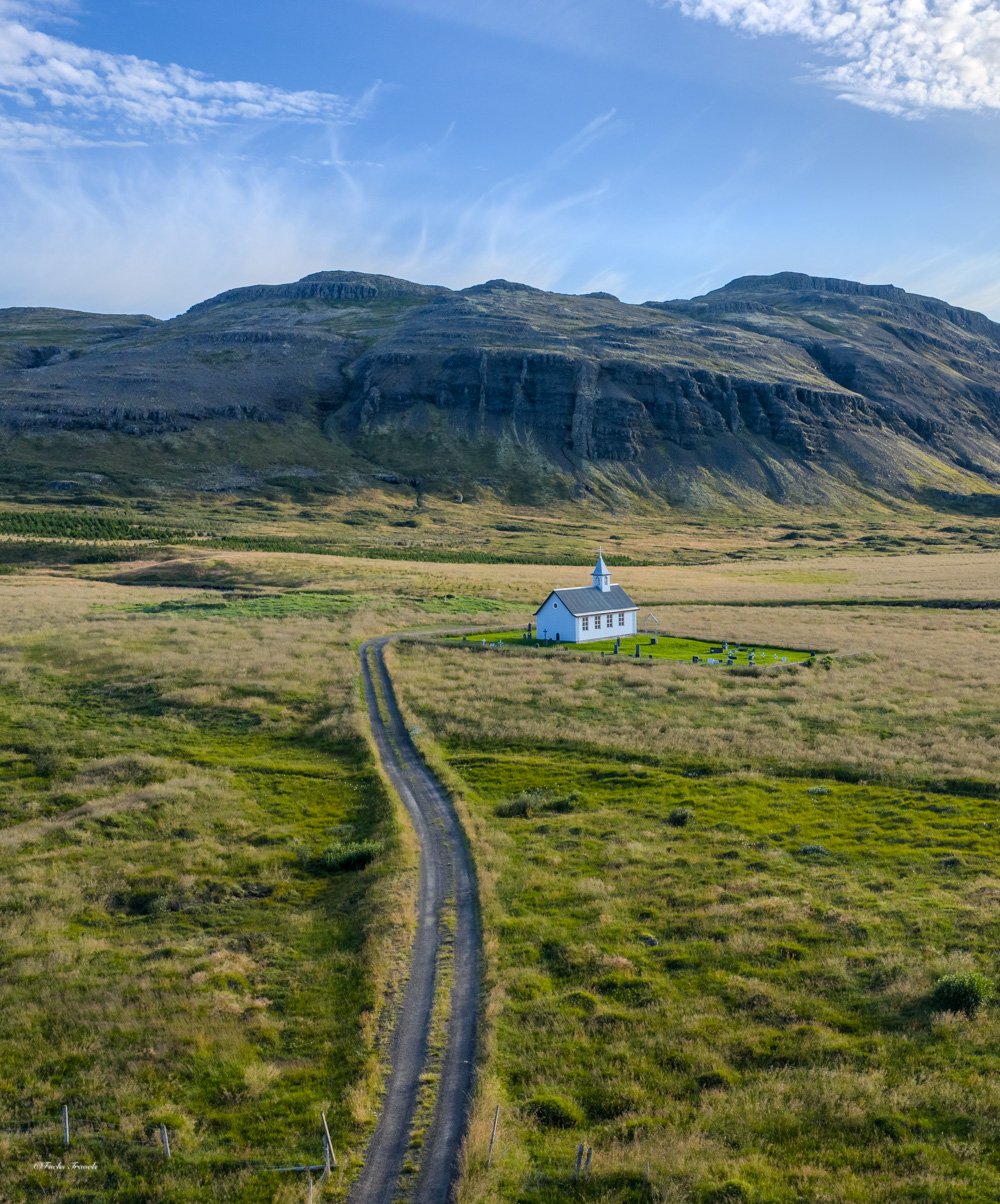
Photo: Robert Lukeman
Snaefellsnes Peninsula: Iceland in Miniature
The Snaefellsnes Peninsula concentrates nearly every Icelandic landscape type into a single peninsula. Mountains, glaciers, lava fields, sea cliffs, and fishing villages within an hour’s drive of each other.
7. Kirkjufell
GPS: 64.XX°N, 23.XX°W🔒 | Best light: Blue hour, aurora season | Difficulty: Easy
The most photographed mountain in Iceland. Kirkjufell’s distinctive shape, combined with the Kirkjufellsfoss waterfall in the foreground, creates the composition that appears on every Iceland photography list.
Field notes:
- The classic composition places Kirkjufellsfoss in the foreground with the mountain centered behind. Use a 24-35mm focal length from the established viewpoint.
- During aurora season (September-March), this is one of the premier northern lights photography locations. The mountain provides a compelling foreground anchor for aurora compositions.
- Arrive before sunrise. This is arguably the most crowded photography location in Iceland, and tripod space at the primary viewpoint is limited.
- Consider alternative angles. Walk further along the road for profiles that show Kirkjufell’s distinctive arrowhead shape without the waterfall.
8. Londrangar Sea Stacks
GPS: 64.XX°N, 23.XX°W🔒 | Best light: Sunset | Difficulty: Easy
Two basalt plugs rising from the coastline, remnants of an ancient volcanic crater. The taller column reaches 75 meters.
Field notes:
- Multiple viewpoints from the parking area. Walk the path to find compositions that layer the stacks against the Snaefellsjokull glacier.
- Summer wildflowers (June-July) add color to the foreground. Low-angle compositions with flowers and stacks create depth.
- Sunset light hits the western faces directly. The warm light on dark basalt is striking.
9. Arnarstapi
GPS: 64.XX°N, 23.XX°W🔒 | Best light: Morning to midday | Difficulty: Easy
A harbor village with dramatic coastal basalt formations, a natural sea arch, and a coastal walking path to nearby Hellnar.
Field notes:
- The coastal path between Arnarstapi and Hellnar (2.5 km) is one of the finest short walks in Iceland for photography. Basalt formations, sea caves, and nesting birds throughout.
- The natural arch frames Snaefellsjokull glacier when conditions are clear.
- Less crowded than Kirkjufell. You can work compositions here without competing for space.
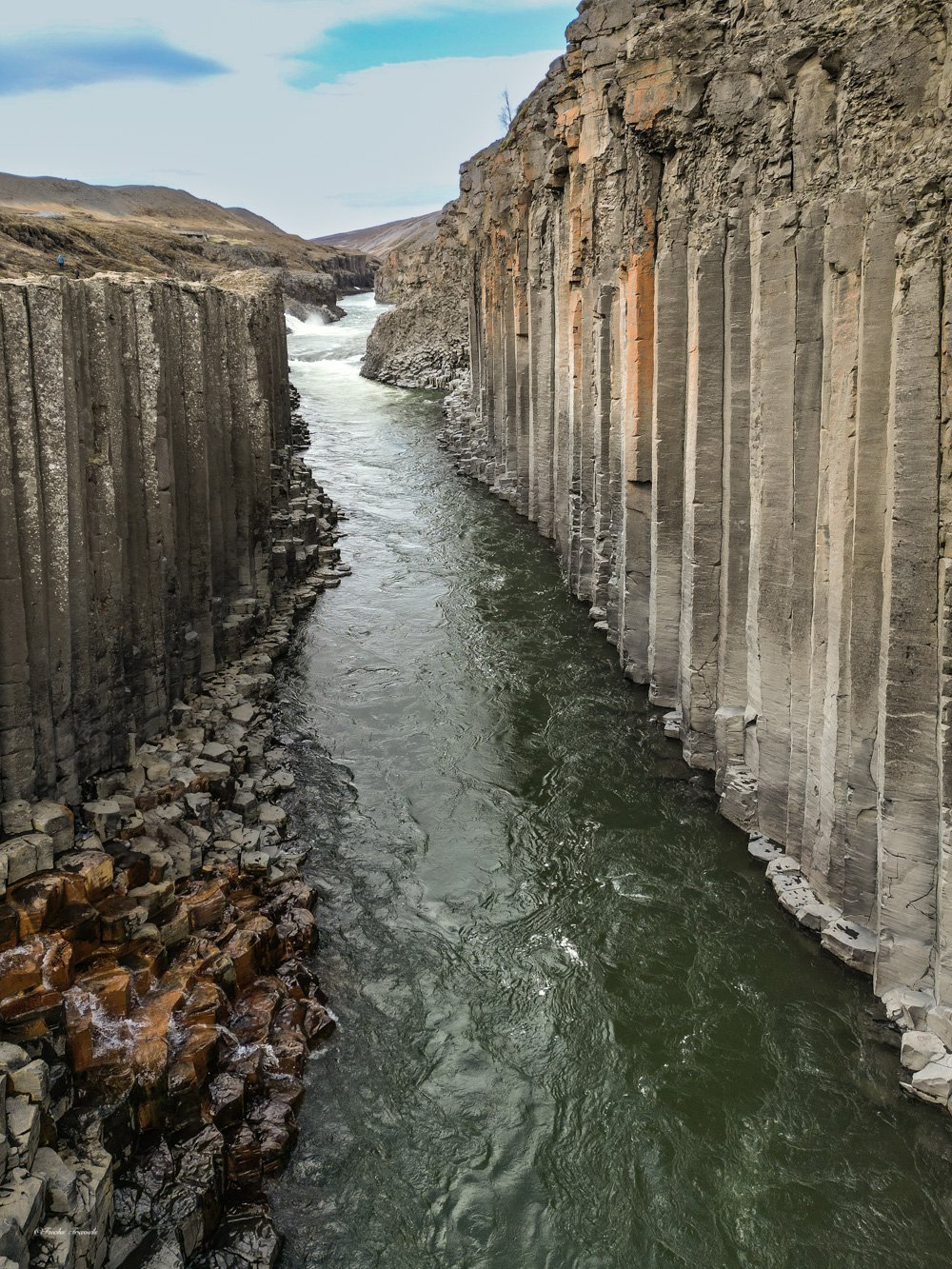
Photo: Amin Ghadersohi
East Iceland: The Quiet Powerhouse
East Iceland receives a fraction of the visitors that the south coast draws, yet contains some of the island’s most dramatic landscapes. The drive from Hofn to Egilsstadir along the eastern fjords is spectacular.
10. Stokksnes / Vestrahorn
GPS: 64.XX°N, 14.XX°W🔒 | Best light: Sunrise, sunset | Difficulty: Easy (fee required)
Vestrahorn is a 454-meter gabbro and granophyre mountain that rises sharply from black sand dunes. The combination of jagged peaks, dune grass, and tidal flats creates compositions that shift dramatically with light and tide.
Field notes:
- Access requires a fee paid at the Viking Cafe (small, worthwhile). This grants unlimited access.
- Low tide reveals intricate patterns in the black sand and creates shallow reflections of the mountain. Check tide tables and plan accordingly.
- Sunrise light on the eastern face of Vestrahorn is the premier shot. The warm light contrasts with the dark sand.
- Drone photography reveals the scale of the dune patterns impossible to appreciate from ground level.
- The abandoned Viking film set on the dunes adds an unusual foreground element.
11. Eystrahorn
GPS: 64.XX°N, 14.XX°W🔒 | Best light: Sunrise, calm conditions | Difficulty: Easy
Vestrahorn’s less-visited neighbor offers equally dramatic mountain scenery with a tidal lagoon that creates mirror-perfect reflections.
Field notes:
- Virtually no crowds, even in peak season. You can work this location alone.
- The tidal lagoon reflection requires calm conditions. Early morning before wind picks up is essential.
- Combine with Vestrahorn for a full day of shooting.

Photo: Amin Ghadersohi
The Highlands: Summer-Only Access
Iceland’s interior highlands are accessible only from roughly mid-June through September via F-roads that require a capable 4x4 vehicle. River crossings are common and can be dangerous. But the landscapes here are among the most alien on Earth.
12. Landmannalaugar
GPS: 63.XX°N, 19.XX°W🔒 | Best light: Midday (colors) and golden hour | Difficulty: Moderate (F-road access)
Rhyolite mountains in colors that look digitally manipulated but are entirely natural: orange, green, purple, red, and yellow striped across the hillsides.
Field notes:
- Accessible only June-September. Check road conditions at road.is before departing.
- Unlike most landscape locations, midday light actually works here. The high sun saturates the mineral colors.
- Hike the first section of the Laugavegur trail for elevated viewpoints that reveal the full color spectrum.
- Aerial/drone perspective is transformative at this location. The color patterns are most visible from above.
13. Sigoldugljufur (Valley of Tears)
GPS: 64.XX°N, 19.XX°W🔒 | Best light: Overcast or golden hour | Difficulty: Moderate to strenuous
A canyon where multiple waterfalls cascade from both walls simultaneously. One of Iceland’s most spectacular scenes and still relatively unknown.
Field notes:
- Requires F-road access with a high-clearance 4x4.
- The hike down to canyon level provides the most dramatic compositions.
- Overcast conditions reduce contrast and allow longer exposures on the waterfalls.
- Bring a wide-angle lens (14-24mm) to capture the full scope of the canyon.
Northern Iceland
14. Godafoss
GPS: 65.XX°N, 17.XX°W🔒 | Best light: Varies by season | Difficulty: Easy
The “Waterfall of the Gods” where Thorgeir Ljosvetningagodi threw Norse idols after Iceland adopted Christianity in 1000 AD. A horseshoe-shaped falls with access from both banks.
Field notes:
- Access both sides for radically different perspectives. The eastern bank provides the classic wide view; the western bank allows close compositions of individual cascades.
- Winter ice formations transform Godafoss into an entirely different subject. The ice buildup on the falls and surrounding rocks creates abstract sculptural forms.
- Use the river as a leading line from downstream viewpoints.
15. Bruarfoss
GPS: 64.XX°N, 20.XX°W🔒 | Best light: Overcast (enhances blue) | Difficulty: Easy (marked trail)
The bluest waterfall in Iceland. The water achieves an almost artificial-looking turquoise caused by glacial sediment and geological filtering.
Field notes:
- Access is via a marked trail from the parking area. The waterfall has been self-access since 2023.
- Overcast conditions are ideal. Direct sunlight creates harsh contrast and reduces the perception of blue saturation.
- A polarizer cuts glare on the water surface and deepens the blue further.
Additional Locations Worth Your Time
16-20: Waterfalls
- Svartifoss (64.XX°N, 16.XX°W🔒): Basalt column waterfall in Skaftafell. Short hike.
- Dettifoss (65.XX°N, 16.XX°W🔒): Europe’s most powerful waterfall. East side preferred.
- Aldeyjarfoss (65.XX°N, 17.XX°W🔒): Basalt columns surrounding a powerful cascade. F-road access.
- Haifoss (64.XX°N, 19.XX°W🔒): 122-meter falls with adjacent Granni waterfall.
- Oxararfoss (64.XX°N, 21.XX°W🔒): Thingvellir National Park. Historical and geological significance.
21-24: Geological Wonders
- Fjadrargljufur Canyon (63.XX°N, 18.XX°W🔒): 100-meter-deep mossy canyon. Walkable rim.
- Studlagil Canyon (65.XX°N, 15.XX°W🔒): Blue water through basalt columns. Hike required.
- Namafjall / Hverir (65.XX°N, 16.XX°W🔒): Geothermal area with mud pots and fumaroles.
- Stokkseyri (63.XX°N, 21.XX°W🔒): Black sand coast near Reykjavik for aurora.
25-27: Views and Vistas
- Thingvellir (64.XX°N, 21.XX°W🔒): Continental rift. UNESCO site. Geological drama.
- Kerlingarfjoll (64.XX°N, 19.XX°W🔒): Highland geothermal mountains. Summer access only.
- Hornstrandir (66.XX°N, 22.XX°W🔒): Remote Westfjords nature reserve. Boat access only.
Best Times by Location

| Location |
Best Season |
Best Time of Day |
Aurora Potential |
| Jokulsarlon |
Year-round |
Sunrise |
Excellent (Sep-Mar) |
| Vestrahorn |
Year-round |
Sunrise, sunset |
Good |
| Kirkjufell |
Sep-Mar preferred |
Blue hour |
Best in Iceland |
| Landmannalaugar |
Jun-Sep only |
Midday, golden hour |
N/A |
| South Coast Waterfalls |
Year-round |
Varies |
Good |
| Reynisfjara |
Year-round |
Stormy conditions |
Moderate |
| Dettifoss |
May-Oct |
Morning |
Limited |
| Highlands |
Jun-Sep only |
All day |
N/A |
Essential Gear for Iceland
Camera Protection
- Rain sleeves: Not optional. Carry at least 4.
- Lens cloths: Pack 10+. Waterfall spray consumes them.
- Waterproof camera bag cover: Rain can arrive without warning.
- Silica gel packets: Prevent internal condensation when moving between temperature extremes.
Filters
- ND filters (6-stop and 10-stop): Essential for waterfall long exposures
- Polarizer: Cuts spray glare, deepens skies, enhances moss saturation
- Graduated ND (soft edge): Balances bright skies with dark volcanic foregrounds
Tripod
- Rated for wind. Add a weight hook and use it.
- Avoid center column extension in high wind.
- Carbon fiber resists the cold better than aluminum (cold transfer to hands).
- Spike feet for black sand and loose volcanic rock.
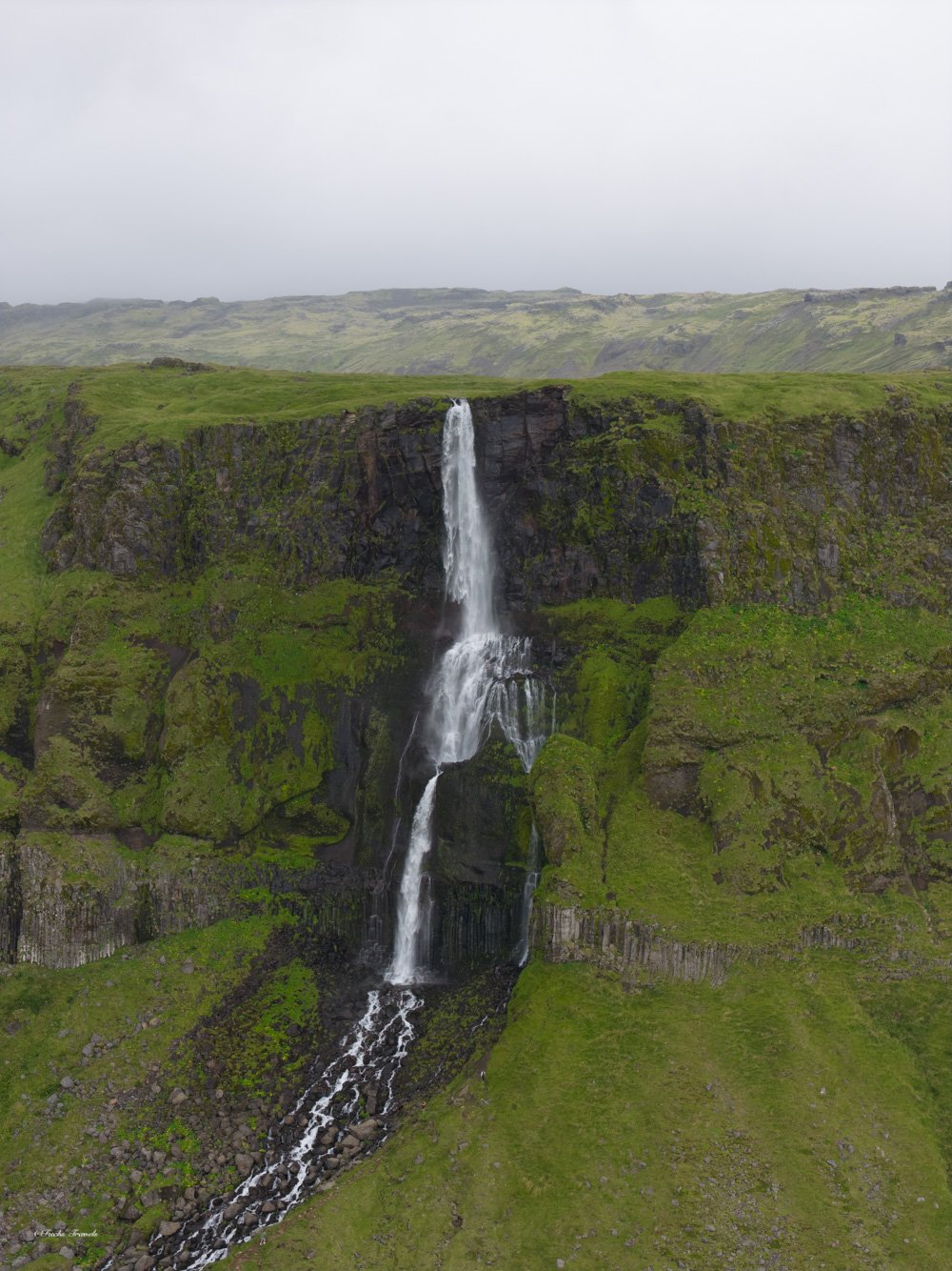
Photo: Amin Ghadersohi
Drone Regulations
- Registration required through the Icelandic Transport Authority for commercial use
- Maintain 150-meter distance from bird cliffs
- No flying within national parks without a specific permit
- Check the Drone Iceland app and My Air Support for current restrictions and no-fly zones
- Iceland’s wind can ground drones unexpectedly. Carry a good anemometer.
Weather Strategy
Iceland’s weather is the single biggest variable in your photography trip. Understanding it is as important as understanding your camera.
Resources
- vedur.is: Iceland’s official meteorological service. The most reliable forecast.
- windy.com: Visualize wind patterns and cloud cover across the island.
- road.is: Real-time road conditions. Critical for highland access.
General Principles
- Weather moves west to east. The south coast gets weather first, the east later.
- Clear skies are rare. Plan for dramatic clouds, not blue sky.
- Wind is the bigger challenge than rain. Your tripod stability strategy matters more than your rain gear.
- Build flexibility into your itinerary. Plan three possible shoots for every evening, and go where conditions favor.

Sample 10-Day Ring Road Itinerary for Photographers
| Day |
Base |
Primary Locations |
Backup |
| 1 |
Reykjavik |
Thingvellir, Golden Circle |
Bruarfoss |
| 2 |
Vik |
Seljalandsfoss, Skogafoss |
Fjadrargljufur |
| 3 |
Vik |
Reynisfjara, Dyrholaey |
Black sand beaches |
| 4 |
Hofn |
Jokulsarlon, Diamond Beach |
Svartifoss |
| 5 |
Hofn |
Vestrahorn, Eystrahorn |
Eastern fjords |
| 6 |
Egilsstadir |
Studlagil Canyon, Dettifoss |
East coast villages |
| 7 |
Akureyri |
Godafoss, Namafjall |
Aldeyjarfoss |
| 8 |
Snaefellsnes |
Kirkjufell, Londrangar |
Arnarstapi-Hellnar |
| 9 |
Snaefellsnes |
Flexible reshoot day |
Peninsula exploration |
| 10 |
Reykjavik |
Return, Golden Circle gaps |
Departure |
Photo: Amin Ghadersohi
Transportation and Logistics
Vehicle Requirements
- Ring Road (Route 1): A 2WD vehicle is technically adequate in summer, but a 4x4 provides access to F-roads, highland detours, and rough tracks to lesser-known locations.
- Highlands (F-roads): 4x4 mandatory. Not optional, not flexible. River crossings require high clearance.
- Winter (October-April): 4x4 strongly recommended everywhere. Studded tires available from rental agencies.
Rental Strategy
- Book a 4x4 far in advance, especially for summer. Availability is limited.
- Add gravel/sand/ash protection insurance. Iceland’s roads throw debris.
- Understand river crossing coverage. Most standard policies exclude it. Supplemental coverage is available.
- Never park on the roadside where volcanic sand is blowing. It will strip your rental’s paint.
Safety Essentials
- Reynisfjara and other south coast beaches: Sneaker waves are lethal. Respect posted warnings.
- Glacier lagoon edges: Unstable and deceptively dangerous. Stay on marked paths.
- Highland river crossings: Deep, cold, and fast-moving. Only cross in convoy with experienced drivers.
- Weather exposure: Hypothermia is possible year-round. Layer properly and carry emergency supplies.
- Geothermal areas: Boiling water and unstable ground. Stay on boardwalks.
As Galen Rowell’s work in Mountain Light demonstrates, the most powerful landscape photographs combine dramatic natural conditions with the photographer’s willingness to be uncomfortable. Iceland provides both in abundance. The reward is a body of work unlike anything you can capture elsewhere on Earth.