The Landscape That Taught Chinese Painters How to See
You have seen Guilin before. Not in person, perhaps, but in every Chinese landscape painting that has ever caught your eye: impossible limestone spires rising from flat river valleys, their bases wrapped in mist, their peaks dissolving into cloud. For a thousand years, painters traveled to this region of southern China and returned home convinced that no other landscape on Earth combined water, stone, and atmosphere with such effortless drama. They were not wrong.
Standing on the summit of Xianggong Mountain at dawn, watching the Li River snake through a forest of karst peaks while morning mist pools in every valley below, you understand why the Chinese have a saying: “Guilin’s scenery is the finest under heaven.” The landscape is not merely photogenic. It is compositionally generous in a way that few places are. Every direction offers layered depth, tonal gradation from foreground to infinity, and the kind of atmospheric perspective that landscape photographers spend entire careers trying to manufacture in post-processing. Here, nature hands it to you for free.
But Guilin rewards preparation over spontaneity. The mist that makes Xianggong Mountain transcendent at 5:30 AM burns off by 9:00. The cormorant fishermen who light their lanterns at dusk along the Li River work on a schedule that does not wait for photographers still fumbling with tripod legs. The Longji rice terraces shift from bare mud to flooded mirrors to golden waves across a seasonal calendar that you must understand before booking flights. And China’s drone regulations, tightened considerably in 2024 and 2026, require registration and planning that cannot be done at the airport.
This guide covers the locations, the timing, the technical approach, and the logistics for a serious photography expedition to one of the most visually rich regions on the planet.
The Karst Landscape: Understanding What You Are Photographing
Guilin’s karst topography formed over 300 million years. Limestone deposited on an ancient seabed was uplifted, then dissolved by mildly acidic rainwater over millennia, leaving behind the tower karst formations that define the region. The result is a landscape of vertical limestone pillars, some rising 100 meters or more from the valley floor, separated by flat alluvial plains where the Li River and its tributaries have deposited sediment.
This geological history matters for photography because it explains the visual character of the region: sharp vertical forms against horizontal planes, hard rock against soft water, solid mass against dissolving mist. The compositions practically build themselves once you understand the structural logic of the terrain.
The Role of Atmosphere
Guilin sits in a subtropical humid climate zone at approximately 25 degrees north latitude. High humidity, frequent temperature inversions between river valleys and mountain summits, and the thermal dynamics of limestone heating and cooling create mist and fog conditions that are central to the region’s photographic character. This is not incidental weather. It is the defining visual element.
The mist is most reliable from September through November and March through May. In these shoulder seasons, the probability of waking to valley fog that lifts gradually through the morning, revealing successive layers of karst peaks, exceeds 60 percent on any given day. Summer heat burns mist off too quickly. Winter can produce fog but the cold and overcast skies limit the warm tonal palette that makes Guilin images sing.
Key Photography Locations
Guilin’s photographic territory spans roughly 80 kilometers from the Longji rice terraces in the north to Yangshuo in the south, with the Li River connecting the major locations. Each site has optimal timing that is specific and non-negotiable. Arrive late, and you photograph a different, lesser place.
Sign up to see photography location maps
Xianggong Mountain: The Defining Shot
GPS: 24.XX°N, 110.XX°E🔒 | Best light: Pre-dawn through early morning | Difficulty: Moderate (steep climb, 20 minutes)
Xianggong Mountain is the single most important photography location in the Guilin region. The summit viewpoint, reached via a steep stone stairway, provides a panoramic view across the Li River as it bends through a corridor of karst peaks. On a clear morning with valley mist, this view is arguably the finest landscape panorama in all of China.
Field strategy:
- Arrive at the base at least 60 minutes before sunrise. The climb takes 20 minutes, and securing a position at the viewpoint railing matters. During peak season, tripod positions fill quickly.
- The composition works at every focal length. A 16-35mm captures the full panorama of river bends and karst forest. A 70-200mm isolates individual peak clusters rising from mist. Shoot both.
- The mist behavior follows a pattern: it is thickest at first light, begins to thin as the sun warms the valley floor, and often creates a layered effect where the nearest peaks are clear while distant peaks fade into atmospheric haze. This layering is the key compositional element. Wait for the moment when three or four distinct layers of depth are visible.
- A polarizing filter cuts haze and deepens the blue sky above the peaks, but rotate carefully. Over-polarizing can darken the sky unevenly in wide-angle panoramas.
Lens recommendations: 24-70mm f/2.8 as primary, 70-200mm f/2.8 for compression, 16-35mm for sweeping panorama.
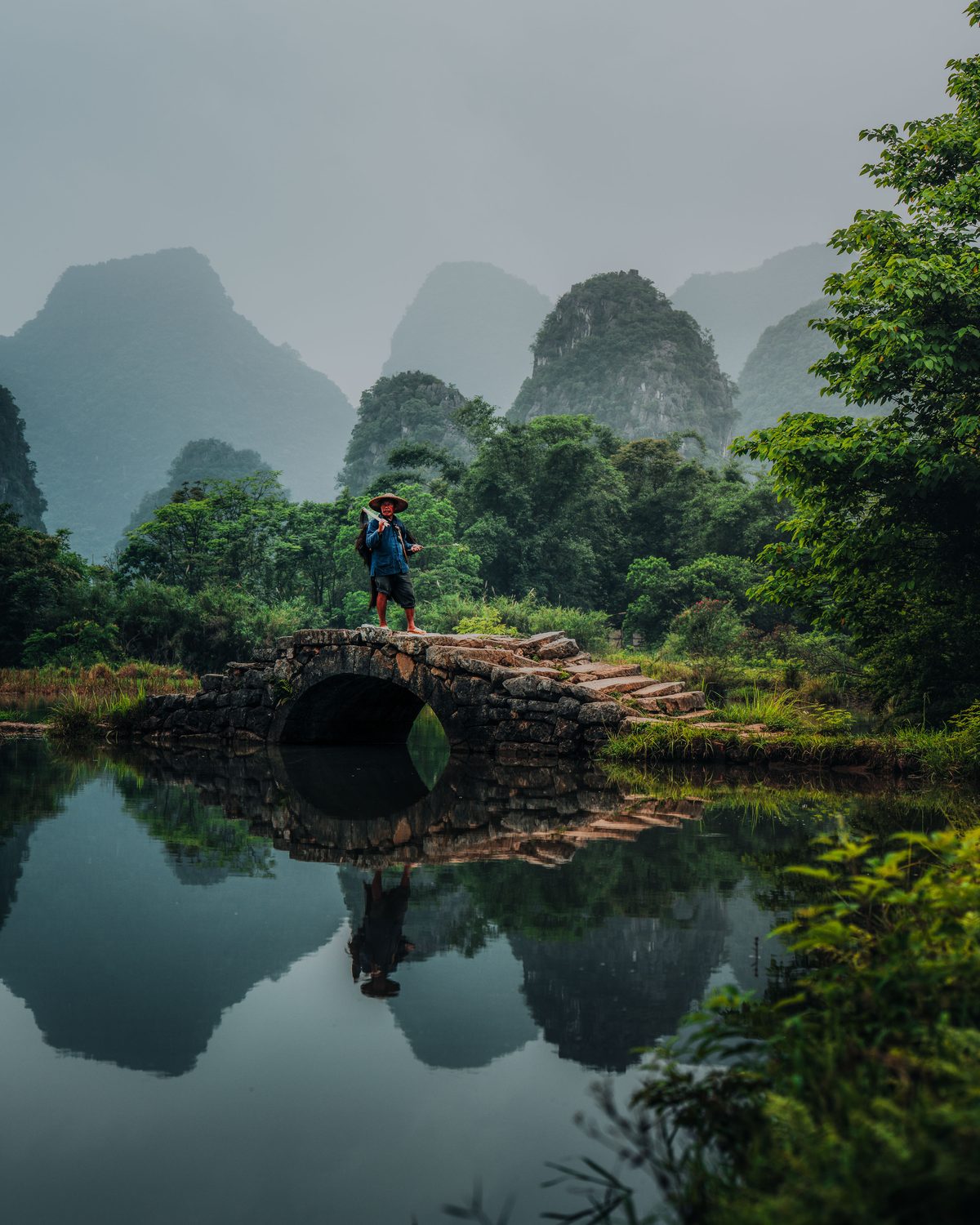
Photo: Ronald Soethje
Longji Rice Terraces: Ping’An Village
GPS: 25.XX°N, 110.XX°E🔒 | Best light: Sunrise, golden hour | Difficulty: Easy to moderate (village walks, some steep paths)
The Longji (Dragon’s Backbone) terraces cascade down mountainsides for hundreds of vertical meters, their curving lines following contours carved by Zhuang and Yao farmers over 700 years. For photographers, the terraces are a masterclass in leading lines, pattern, and seasonal transformation.
The two essential viewpoints:
-
Nine Dragons and Five Tigers (25.XX°N, 110.XX°E🔒): The most famous viewpoint, offering a sweeping view across terraces that resemble the scales of a dragon descending the mountainside. Best at sunrise when mist fills the valleys between terrace ridges. The “nine dragons” are ridgelines; the “five tigers” are hilltops. A 24-70mm captures the full sweep; a 70-200mm isolates individual terrace sections where the curved lines are tightest.
-
Seven Stars with Moon (25.XX°N, 110.XX°E🔒): Named for the arrangement of small hilltops surrounded by terraces, this viewpoint produces the most iconic Longji composition. The seven “stars” are terraced knolls, and the “moon” is a larger central hill. This location is best at sunrise when mist wraps around the lower terraces and the sun backlights the ridgeline.
Seasonal timing is everything:
| Season |
Terrace State |
Photography Value |
| April - May |
Flooded paddies reflecting sky and clouds |
Peak: mirror reflections at sunrise |
| June - July |
Young green rice shoots, lush |
Strong: vivid green layering |
| August |
Mature deep green |
Good: dense, uniform green |
| September - October |
Golden harvest, ripe grain |
Peak: golden terraces in warm light |
| November - March |
Brown, dormant, or bare |
Limited: graphic patterns only |
The two peak windows, flooded terraces in April-May and golden harvest in September-October, produce fundamentally different images. The flooded terraces create mirror surfaces that reflect sky, clouds, and surrounding peaks, doubling every composition. The golden harvest turns the terraces into flowing rivers of warm color that catch sidelight and glow. Both are extraordinary.

Lingui Glass Fields
GPS: 25.XX°N, 110.XX°E🔒 | Best light: Sunrise | Difficulty: Easy (roadside access)
The Lingui glass fields are flooded rice paddies on the flat alluvial plain south of Guilin city, surrounded by karst peaks. When flooded in spring (April through May) or after heavy rain in autumn, the paddies become perfect mirrors reflecting the karst skyline. The effect is surreal: an infinity of jagged limestone peaks doubled in still water, with a farmer or water buffalo providing the compositional anchor.
Shooting tips:
- A low camera position (tripod at minimum height or even ground level) maximizes the reflection area in the frame.
- Use a 24-70mm to include both the reflection and the surrounding karst peaks. A 16-35mm risks including too much empty sky.
- Arrive before the wind picks up. By 8 AM, thermal breezes typically ripple the water surface and destroy the mirror effect.
- A graduated ND filter (2-3 stops, soft edge) balances the bright sky with the darker reflection in the water.

Photo: Ronald Soethje
Cuiping Five Finger Mountain
GPS: 24.XX°N, 110.XX°E🔒 | Best light: Late afternoon through sunset | Difficulty: Easy
Cuiping Hill offers an elevated viewpoint overlooking a village nestled among five karst peaks that resemble an open hand. The scene below is a working agricultural landscape: rice paddies, vegetable plots, and village houses with smoke rising from cooking fires in the late afternoon. This is the location where Guilin’s landscape and cultural photography intersect most naturally.
Composition approach:
- The five peaks provide a natural framing device. Position the village in the middle ground with the peaks rising behind it.
- Late afternoon light rakes across the valley floor, creating long shadows from the karst peaks that add depth and dimension.
- Include human activity: farmers returning from fields, children playing, smoke rising from kitchens. These elements transform a landscape into a story.
- A 70-200mm isolates individual village scenes within the larger landscape. A 24-70mm captures the full five-finger panorama.
Yuanbao Hill and the Cormorant Fishermen
GPS: 24.XX°N, 110.XX°E🔒 | Best light: Sunset through blue hour | Difficulty: Easy
Yuanbao Hill provides an elevated platform above the Li River where cormorant fishermen stage their evening work. This is where one of China’s most iconic photographic traditions unfolds: elderly fishermen on bamboo rafts, their trained cormorants perched on long poles, gas lanterns casting warm pools of light across the dark water while karst peaks silhouette against the fading sky.
What to expect: The cormorant fishing you will photograph is a cultural demonstration, not active commercial fishing. Cormorant fishing as a livelihood has largely disappeared, replaced by tourism revenue from photographers. The fishermen are real, their skills are authentic, and the birds are genuine working cormorants, but the sessions are staged for photographers. Knowing this matters because it means the fishermen will cooperate with positioning requests, repeat actions, and work through the full light transition from golden hour to blue hour.
The three-phase shoot:
The cormorant session typically runs from approximately 30 minutes before sunset through 40 minutes after, giving you three distinct lighting phases, each requiring different settings and producing different images.

Phase 1 - Golden Hour: The fisherman is a silhouette against the warm sky and karst peaks. Use the sky as your exposure reference. The fisherman and cormorants become graphic shapes against color. This is the wide-angle phase: capture the full scene with the river, peaks, and raft.
Phase 2 - Sunset Transition: As the sun drops below the karst horizon, the lanterns become visible. The color contrast between warm lantern light and cool ambient sky creates the most balanced exposures. This is the sweet spot. Shoot continuously.
Phase 3 - Blue Hour: The sky deepens to cobalt, the lantern becomes the dominant light source, and its reflection streaks across the dark water. Switch to a wider aperture and higher ISO. The mood shifts from documentary to ethereal. Consider a 1-2 second exposure to create a slight mist effect on the water surface.
Critical tips:
- Bring a 70-200mm f/2.8. The close-up of the fisherman’s weathered face lit by lantern light, with a cormorant on his shoulder, is the money shot. You need the reach and the fast aperture.
- Position yourself slightly downstream of the raft so the lantern reflection streaks toward your camera.
- The fisherman will throw his net on request. The net frozen mid-air, lit by lantern against blue sky, is a powerful composition. Communicate through your guide or tour leader.
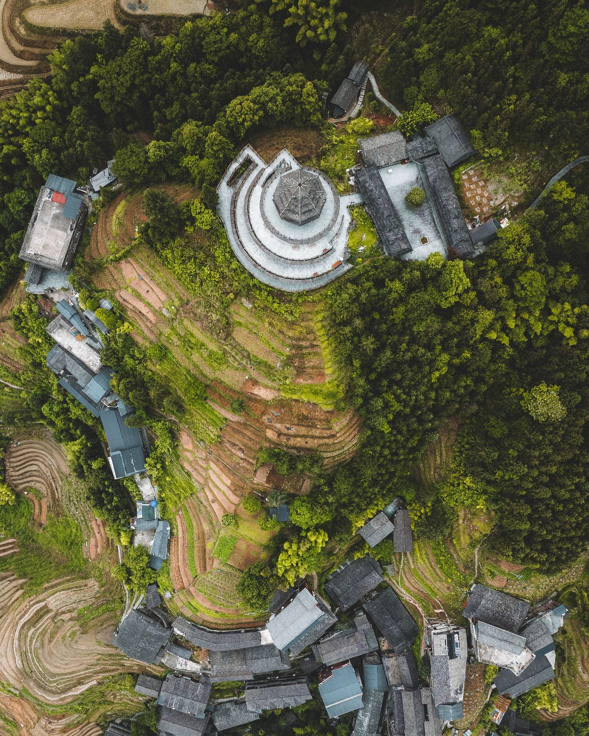
Photo: Ronald Soethje
Yangshuo: Yulong River and Surrounding Landscapes
GPS: 24.XX°N, 110.XX°E🔒 | Best light: Early morning, late afternoon | Difficulty: Easy
Yangshuo is the southern anchor of the Guilin photography corridor. The town itself is tourist-saturated and photographically unremarkable, but the surrounding countryside along the Yulong River contains some of the most accessible karst scenery in the region.
Key shots from Yangshuo:
- Yangshuo Bridge at sunrise: The old stone bridge with karst peaks reflected in the river below. Arrive 30 minutes before sunrise. A 24-70mm captures bridge, river, and peaks in a single frame.
- Yulong River cycling route: Rent a bicycle and follow the river road for 15 kilometers. The route passes through rice paddies, bamboo groves, and village scenes with constant karst backdrop. Stop at every ancient bridge you encounter. The stone bridges with their arched reflections in the river create perfectly symmetrical compositions.
- Wulong Spring: A sunset location where the Li River widens and the karst peaks catch the last warm light. The wide river creates reflections that double the mountain forms.
Drone Photography in Guilin
The aerial perspective transforms Guilin’s karst landscape from dramatic to otherworldly. From 60-120 meters, the Li River reveals its full serpentine path through the peak forest, the rice terraces become abstract geometric patterns, and the morning mist creates layered depth that is invisible from ground level.
China Drone Regulations: What You Must Know
China tightened drone regulations significantly with the Unmanned Aircraft Flight Management Regulations that took effect January 1, 2024, with further enforcement measures added in 2026. Flying a drone in China as a foreign tourist is legal but requires advance preparation.
Registration (mandatory):
- All drones, regardless of weight, must be registered with the Civil Aviation Administration of China (CAAC) through the UOM (Unmanned Aircraft Real-Name Registration System) online portal.
- Registration requires a Chinese phone number. Obtain a local SIM card upon arrival in Guilin, or arrange one through your hotel or tour operator before your first flight. An English-language registration option became available in 2025.
- Your CAAC registration number must be displayed on the drone.
Operational rules:
- Maximum altitude: 120 meters above ground level.
- Visual line of sight (VLOS) required at all times.
- No flying in controlled airspace (airports, military installations, government buildings) without specific authorization.
- No flying over crowds, highways, or densely populated areas.
- Night flights require additional approval.
- Drones over 250 grams require liability insurance.
Guilin-specific considerations:
- Xianggong Mountain: Drone flights from the summit area are possible but confirm current local restrictions with your guide. The area is not a formal no-fly zone, but enforcement can be inconsistent.
- Longji Rice Terraces: The terraces are a scenic area with their own management. Drone use is generally tolerated in the early morning before crowds arrive, but the viewpoint platforms during busy hours are not appropriate launch sites. Fly from quiet areas away from main tourist paths.
- Li River corridor: The Li River between Guilin and Yangshuo is heavily trafficked by tour boats. Avoid flying directly over the main river channel during boat traffic hours (approximately 8 AM to 4 PM).
- Villages: Always ask permission before flying over or near inhabited villages. Cultural respect is not optional.
Practical recommendation: Register your drone before leaving your home country if possible, or immediately upon obtaining a Chinese SIM card. Carry your registration confirmation at all times. A sub-250g drone like the DJI Mini 4 Pro faces fewer regulatory hurdles but is vulnerable to the thermal updrafts that karst terrain generates on warm afternoons. The DJI Mavic 4 Pro or Air 3S handle Guilin’s conditions with more stability and produce files that match the quality of your ground-based work.
Best Aerial Compositions
| Location |
Altitude |
Composition |
Notes |
| Xianggong Mountain area |
80-120m |
Li River bends through peak forest |
Dawn mist, the defining aerial shot |
| Longji terraces |
40-80m |
Terrace curves and village rooftops |
Morning light raking across contours |
| Lingui glass fields |
20-40m |
Nadir: mirrored paddies and karst reflections |
Ultra-low altitude, still morning |
| Cuiping village |
60-100m |
Village among five peaks |
Late afternoon, smoke from kitchens |
| Yulong River bridges |
30-60m |
Ancient stone bridges with reflections |
Low oblique angle for bridge detail |
| Cormorant fisherman area |
20-50m |
Raft, lantern, river, and karst peaks |
Sunset to blue hour, CAUTION: low light |

Photo: Ronald Soethje
Seasonal Planning: When to Visit
Guilin’s subtropical climate means photography is possible year-round, but the gap between a well-timed visit and a poorly timed one is enormous.
The Two Peak Windows
April through May (Flooded Terraces): The Longji rice terraces are flooded and planted, creating mirror surfaces that reflect sky and peaks. The karst lowlands around Lingui are similarly flooded. Temperatures are comfortable (16-28C), and mist frequency is high. The downsides: spring rain can be persistent, with multi-day stretches of overcast conditions. April rainfall averages 220mm in Guilin.
September through October (Golden Harvest): The rice terraces turn gold, the summer monsoon has ended, temperatures drop to comfortable levels (22-29C in September), rainfall decreases sharply to 75-80mm per month, and the mist that defines Guilin’s atmospheric character returns with the cooling temperatures. This is the window that most serious photographers target. The golden terraces in warm morning sidelight, with mist threading through the karst valleys below, represent the pinnacle of Guilin photography.
Months to Avoid
July and August: The summer monsoon brings heavy rain, extreme humidity, temperatures exceeding 33C, and haze that flattens the atmospheric layering. The heat also makes dawn shoots physically uncomfortable and kills mist formation. Unless you specifically want lush green terraces and are willing to endure the conditions, skip midsummer.
December through February: While winter brings occasionally clear skies and interesting frost on the terraces, the bare brown paddies lack the visual drama of flooded or golden states. Temperatures drop to 5-10C, which is manageable, but the short days and frequent overcast limit shooting opportunities.
A Seven-Day Photography Itinerary
This itinerary is designed for mid-September, the golden harvest peak. Adjust timing for April-May if targeting flooded terraces.
| Day |
Locations |
Focus |
Wake Time |
| 1 |
Arrive Guilin |
City orientation, gear check, test drone registration |
– |
| 2 |
Ping’An Village, Longji Rice Terraces |
Nine Dragons sunrise, Five Tigers golden hour, Zhuanguan Bridge |
4:30 AM |
| 3 |
Seven Stars with Moon, Longmen Bridge |
Terraces sunrise from alternate viewpoint, Longmen Bridge sunset |
4:30 AM |
| 4 |
Lingui Glass Fields, Cuiping Five Finger Mountain |
Flooded paddy reflections at sunrise, village scenes at sunset |
4:45 AM |
| 5 |
Xianggong Mountain, Langshi Village, Yuanbao Hill |
Li River panorama at dawn, village walk, cormorant fishermen at sunset |
4:00 AM |
| 6 |
Yangshuo Bridge, Yulong River, Wulong Spring |
Bridge reflections at sunrise, river cycling, sunset |
5:00 AM |
| 7 |
Departure or reshoot |
Return to strongest location based on conditions, depart |
Variable |
Itinerary notes:
- The drive from Guilin city to the Longji Rice Terraces takes approximately 2.5 hours. Plan accommodation near Ping’An Village (Baike Boutique Hotel or similar) for Days 2-3 to eliminate the commute and enable dawn access.
- Xianggong Mountain requires the earliest wake-up because the mist window is the shortest. Prioritize this location above all others.
- Day 7 functions as a weather insurance day. If mist conditions were poor at Xianggong on Day 5, return for a second attempt.
- A local photography guide or driver who knows the roads, the light, and the current terrace conditions is not a luxury. It is the difference between finding the right viewpoint in darkness and missing the mist window.
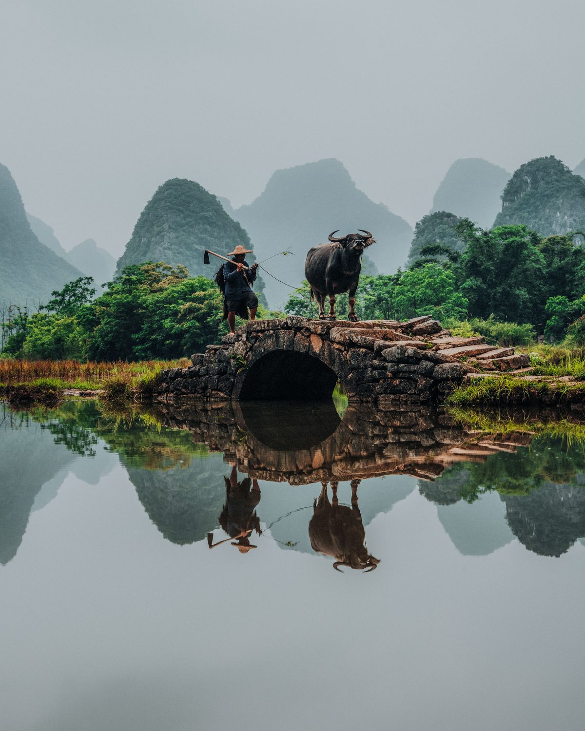
Photo: Ronald Soethje
Cultural Photography Etiquette
China presents specific cultural considerations that differ from Western photography norms. Guilin’s rural areas, where Zhuang and Yao minority communities maintain traditional lifestyles, demand particular sensitivity.
Working in Villages
- Ask before photographing people. A smile and a gesture toward your camera is usually sufficient. Most villagers in tourist areas are accustomed to photographers and may welcome the attention, but consent is not automatic.
- The Yao women of Longji are famous for their extraordinarily long hair, which they wear coiled in elaborate arrangements. They will sometimes pose for photographs in exchange for a small tip (10-20 RMB). This is a fair cultural exchange, not exploitation, when conducted respectfully.
- Temple and shrine photography: Remove your hat, lower your voice, and never use flash. Some shrines prohibit photography of specific deity statues. Look for signs or follow what local visitors do.
- Avoid photographing military installations, government buildings, or police. This is a legal requirement in China, not merely etiquette.
David duChemin’s principle from Within the Frame applies here with particular force: the most respectful photographs require you to be present in the moment before pressing the shutter. The villages around Guilin are not sets. They are homes.
Language
English is minimally spoken outside Guilin city and Yangshuo tourist areas. Learn a few Mandarin phrases: “Ke yi pai zhao ma?” (May I take a photo?) goes a long way. Having your guide facilitate introductions in villages produces better photographs and better human connections.
Equipment Recommendations
Camera and Lens Kit
Guilin rewards a versatile kit that handles both sweeping landscapes and intimate cultural moments. The humidity and potential for rain demand weather-sealed bodies.
| Item |
Recommendation |
Why |
| Body |
Weather-sealed mirrorless (Sony A7R V, Nikon Z8, Canon R5 II) |
Humidity, mist, morning dew on gear |
| Wide zoom |
16-35mm f/2.8 |
Terrace panoramas, karst sweeps, village interiors |
| Standard zoom |
24-70mm f/2.8 |
Workhorse for 70% of shots |
| Telephoto |
70-200mm f/2.8 |
Cormorant close-ups, karst compression, terrace isolation |
| Fast prime |
35mm f/1.4 or 50mm f/1.4 |
Village interiors, low light cultural moments |
| Tripod |
Carbon fiber travel |
Dawn shoots, long exposure water, drone launches |
| Drone |
DJI Mavic 4 Pro or Air 3S |
Aerial karst and terrace compositions |
| Filters |
Polarizer, 3-stop soft GND, 6-stop ND |
Haze cutting, sky balance, water smoothing |
The Polarizer Is Non-Negotiable
In Guilin, a circular polarizing filter is your single most important accessory after your lens. It cuts the atmospheric haze that builds between karst layers, deepens the blue sky above the peaks, saturates the greens and golds of the rice terraces, and eliminates glare on flooded paddies to reveal the reflected peaks beneath. Carry one sized for your most-used lens and use it on every outdoor shoot.
Humidity Protection
Guilin’s humidity regularly exceeds 80 percent. Your gear will condensate when moving from air-conditioned spaces to the outdoor environment.
- Carry silica gel packets in every compartment of your camera bag.
- Let your camera acclimatize for 15 minutes in a sealed bag before shooting after leaving an air-conditioned room or vehicle. The sealed bag lets condensation form on the bag exterior rather than on your lens elements.
- Wipe lens elements frequently. The combination of humidity and fine particulate from agricultural activity creates a film that softens images.
- Bring a rocket blower for sensor cleaning. Changing lenses in humid conditions invites moisture onto the sensor.

Photo: Ronald Soethje
Practical Logistics
Getting to Guilin
Guilin Liangjiang International Airport (KWL) receives direct flights from major Chinese hubs: Beijing (3 hours), Shanghai (2.5 hours), Guangzhou (1 hour), Chengdu (2 hours), and several international routes including seasonal connections from Bangkok, Kuala Lumpur, and Seoul. From Hong Kong, the fastest route is a flight to Guangzhou followed by a high-speed train to Guilin (approximately 3 hours).
Visa
Most foreign nationals require a visa to enter China. As of 2026, China offers 144-hour visa-free transit for citizens of many countries, but this is limited to specific ports of entry and does not cover all nationalities. Apply for a standard tourist visa (L visa) through your nearest Chinese embassy or consulate well in advance. Processing takes 4-7 business days.
Getting Around
- Hire a driver: For a dedicated photography trip, hiring a driver for the full week is the most efficient option. Rates run approximately 500-800 RMB per day including fuel. Your hotel or tour operator can arrange this.
- High-speed rail: Guilin North station connects to Yangshuo by high-speed train in approximately 25 minutes. However, Yangshuo station is 30 minutes by taxi from Yangshuo town.
- Local transport to Longji: Public buses run from Guilin to Longji, but the schedule does not align with pre-dawn photography arrivals. Private transport is essential for serious work.
Accommodation
| Location |
Recommended |
Character |
| Guilin city |
Shangri-La Hotel Guilin |
5-star base for arrival and departure days |
| Ping’An Village (Longji) |
Baike Boutique Hotel or village guesthouse |
Walking distance to terrace viewpoints, essential for dawn |
| Yangshuo area |
Hampton by Hilton Guilin or riverside guesthouse |
Close to Yulong River and southern karst locations |
Staying inside Ping’An Village for your Longji days eliminates the 2.5-hour drive from Guilin and puts you at the viewpoints in minutes rather than hours. This is the single most important accommodation decision you will make.
Budget Estimate
| Expense |
Approximate Cost |
| Return flights (international + domestic connection) |
$400-1,200 USD |
| Accommodation (6 nights, mixed quality) |
$400-900 USD |
| Private driver (5 days) |
$350-550 USD |
| Meals (7 days) |
$100-200 USD |
| Cormorant fisherman session |
$30-60 USD per person |
| Terrace and scenic area entrance fees |
$50-80 USD total |
| SIM card and drone registration |
$20-30 USD |
Guilin is significantly more affordable than Greenland, Iceland, or Patagonia. A comprehensive seven-day photography expedition, including flights within Asia, can be executed for $1,500-3,000 USD depending on accommodation preferences and flight origin.
Exercises: Preparing for Guilin
Exercise 1: The Mist Layer Drill
Find a local valley or river that produces morning fog. Photograph it from an elevated viewpoint at 15-minute intervals from pre-dawn through two hours after sunrise. Study how the mist layers shift, thin, and reveal the landscape beneath. In Guilin, mist behavior is the primary creative variable, and reading it quickly determines whether you capture the peak moment or miss it by ten minutes.
Exercise 2: The Compression Study
Using a 70-200mm lens at your longest focal length, photograph a scene with multiple layers of depth: trees or buildings at varying distances. Study how telephoto compression stacks the layers. This skill directly applies to photographing karst peaks, where a 200mm lens stacks distant peaks behind near ones, creating the dense layered effect that defines the region’s visual character.
Exercise 3: The Reflection Exposure Test
Find a body of still water reflecting trees or buildings. Photograph the scene at three different exposures: one metered for the sky, one for the reflection, and one balanced between both. Then process each to determine whether a graduated ND filter or exposure blending produces the more natural result. This prepares you for the flooded rice paddy reflections at Lingui and Longji.
Exercise 4: The Blue Hour Portrait
Photograph a person lit by a single warm artificial light source (a candle, a lantern, a small lamp) during blue hour. Practice balancing the warm foreground light against the cool ambient sky. Adjust white balance between 4000K and 6000K and study how each setting changes the emotional register of the image. This is the exact challenge you will face during the cormorant fishermen sessions.
Conclusion
Guilin is not a destination where you show up and point your camera at whatever looks nice. It is a destination where the difference between a postcard and a portfolio image lies in arriving at Xianggong Mountain an hour before everyone else, in understanding that the mist will thin from the east side first, in knowing that September’s golden terraces produce warmer images than April’s mirrored paddies, and in having the cultural sensitivity to photograph village life as a guest rather than a spectator.
The Chinese painters who first documented this landscape understood something that photographers are still learning: Guilin’s beauty is not in the karst peaks themselves. It is in the atmosphere that separates them, the light that sculpts them, and the human activity that gives them scale and meaning. A cormorant fisherman lighting his lantern at dusk is not a prop in your landscape photograph. He is the reason the photograph matters.
Prepare thoroughly. Register your drone before you land. Study the terrace calendar. Learn to read the mist. Then go to Xianggong Mountain in the darkness before dawn, set up your tripod, and wait. The landscape that has been teaching artists to see for a thousand years has a few things to show you, too.